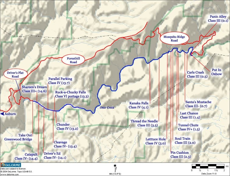
Map of the Middle Fork
Season: May – September
Stretch: Oxbow to Greenwood Bridge
Difficulty: Class III/IV
Distance: 18 miles
Flows: 900 – 2000 CFS, measured as release from Oxbow Dam
Gradient: 23 fpm average, pool and drop
Put-in: Oxbow Powerhouse
Take-out: Below Greenwood Bridge
Shuttle In: 90 minutes AWE to Oxbow. 45 minutes Auburn to Oxbow
Shuttle Out: 50 minutes Greenwood to AWE. 15 minutes Greenwood to Auburn
Wilderness beauty and big drops are the promises when rafting the Middle Fork of California’s American River. The whitewater rafting run that starts just below the Oxbow Powerhouse and includes rapids like the Last Chance, Tunnel Chute, Kanaka, Chunder, Ruck-A-Chucky Falls and heaps more. These rapids demand skilled guides, good paddling technique and world class equipment.
The Middle Fork American River is rated a Class III-IV river and runs through Tahoe National Forest. In addition to the bigger rapids there are also numerous Class II rapids scattered throughout the deep canyon. Large pools follow most of the big rapids allowing you plenty of time to set up for the next rapid or to get regrouped after that unexpected, out-of-boat experience or upside down raft. The rapids on the Middle Fork are created by large boulders and natural slides with the exception of Tunnel Chute.
One of the most notable rapids on the Middle Fork American is the world class Tunnel Chute. This is a man-made rapid created during the mining days of the late 1800’s. Black powder was used to blast through the cliff wall, diverting the water out of the oxbow so it could then be mined for gold. There are many sharp rocks hidden in the chute…so think twice before you decide to fall out or swim it.
The Ruck-A-Chucky Rapid is an unrunnable Class VI 30 foot waterfall. You can portage this rapid via right side trail. The portage itself is about 100 yards long and takes about 30 minutes depending the number of boats you have. This is a great spot to watch how the various guides and rafting companies negotiate the portage. Skill, experience and quite a bit of luck is involved.
Read below and take a VIRTUAL RIDE rafting down the Middle Fork American River…
Mile 0.0
Oxbow Put-In – Arrive and get ready for a fantastic day on the Middle Fork. Guide will unload the rafts and hand out gear to the rafters. There are restrooms for everyone to use. After your safety talk and paddle talk, you’ll be on your way.
Mile 0.1
Good Morning (Class III) – Aptly named rapid is going to make sure you’re awake and paying attention to your guide.
Mile 0.2
North Fork of Middle Fork Canyon
enters the river here. Beautiful creek that carries a lot of water from the snowmelt in the spring.
Mile 0.5
Carls Crash (Class III)
– Always a fun run down but don’t fall out.
Mile 0.7
Santa’s Mustache (Class III)
– This is a fun rapid that can cause a few problems if the raft ends up in a bad spot.
Mile 1.4
Last Chance (Class IV) – This is a near vertical drop that can easily flip or surf a raft. Just below it Tunnel Chute Rapid awaits so when your guide asks you to paddle – make sure you listen.
Mile 1.5
Tunnel Chute (Class IV)
– This rapid was created by some industrious miners in the 1890’s that wanted easy access to the gold rich river bed at Horseshoe Bar. The blasted a tunnel through the narrow part of the horseshoe and then blasted a chute in the bedrock to divert the river to their new tunnel. The sharp rock walls in the chute make this a rapid that you don’t want to swim. This is an amazing rapid and interesting place that all serious California rafters should visit at least once.
Mile 2.0
Soul Train (Class II)
Mile 2.2
Old Gold Tunnel
Mile 2.3
Cathedral (Class III)
Mile 3.0
First Flip or Orange Wall (Class IV)
– Make sure you hold on when running the more aggressive line, if not you are sure to fall out or the raft will flip if you all fall to one side.
Mile 3.5
Thread the Needle (Class III)
Mile 3.8
Three Queen’s (Class III)
Mile 4.1
Kanaka Falls (Class IV)
– The river rushes to the right over a boulder bar and into a cliff that sheds large rocks. Rafts go down the center left side of this rapid. Good idea to paddle well.
Mile 8.1
Doodlebug Dredge (historic landmark)
Mile 10.2
Otter Creek
Mile 13.1
Canyon Creek
Mile 13.2
Chunder (Class IV)
– The “scenic” section ends at Chunder, a fun vertical drop that can be easily scouted on the right. Chunder is immediately followed by a mandatory portage of Ruck-a-Chucky, a 30 foot waterfall onto jagged rocks. There is a new portage trail on the right that can be used to carry your boats.
Mile 13.3
Ruck-A-Chucky Falls (Class VI – portage)
– This rapid used to be un-runnable, but became merely V+ after high water re-arranged big boulders in winter of 1992. Before this rapid became less hazardous, several kayakers had tried to run it; all died or became partially paralyzed.
There is an easy portage path and viewing platform on the right. Some kayakers say that the portage is easier, though exposed, on the left side, but that was before the portage path was built. Some commercial outfitters ghost-boat their rafts over the falls while some guides are comfortable running it. Guests always walk around.
Mile 13.4
Cleavage (Class IV)
Mile 13.7
Parallel Parking (Class IV)
Mile 14.1
Driver’s Ed.
(Class II)
Mile 14.4
Final Exam (Class IV)
Mile 14.6
Pop Quiz (Class III)
Mile 15
Old Greenwood Bridge – Greenwood Bridge site, where a useful bridge washed out in the 1964 flood after Hell Hole dam failed. A nice set of wide stone steps leads up to a parking lot.
Mile 16.0
Oregon Bar